The decoder will decode all
the NMEA
VDM or VDO content
of
all 27 AIS message types including !AIVDM, !BSVDM and
!ABVDM,
The decoder has been tested on an XP PC, and believe it
should work on
all Windows PC's after 98. Other users report it works on
Vista, Win 7,
Win 7-64, Win 8, Win 8.1 and Linux (Wine).
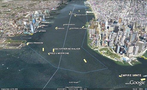
Lower Manhattan
|
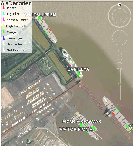
Immingham UK Docks
|
 |
 |
Introduction
Ais Decoder
accepts
AIS data from an AIS Receiver, the Internet or a Local
Network
connection, decodes the data and presents the decoded data
in a form
suitable for display and analysis by mapping program (eg
Google Earth
or Google Maps), or for analysis using Excel, or by a
database (eg
MySql).
Main
Features
| Input: |
Serial or USB from AIS receiver, UDP or TCP
from network,
Log File |
| Input Filter: |
AIS Message type, DAC, FI, ID, MMSI |
| Output: |
Display, File, FTP, UDP
|
Output Frequency
|
As received or at Scheduled intervals
|
| Output Filter: |
Lat/Lon or any other decoded field |
| Output Formats: |
Text, CSV, HTML, XML, KML, KMZ, NMEA |
| Self-extracting
installation
file, including help |
 |
| PDF Help Manual |
 |
AIS
AIS is primarily transmitted by ships
for
collision avoidance. Ships over 200 tons must carry an AIS
transponder
which both transmits and receives AIS data, enabling vessels
to see the
speed and course (and other information) of vessels within around 20 miles
of one
another. It is also used by the Coast Guard and port
authorities to
monitor vessel movements. Other uses are becoming more common,
such as
Virtual Navigation Aids, weather and sea state reporting,
control of
inland waterways such as canals and locks. Anyone with a
suitable
receiver can receive this data.
AisDecoder Specification
- Decodes all
27 Ais Messages types
- Decodes VDM or VDO
sentences (!AIVDM,
!AIVDO, !BSVDM,
!ABVDM etc) messages
- Decodes 50
Binary message types
- All fields are fully
decoded on Detail display
- Input Logging with
optional daily
roll-over
- Decodes messages at 40k-200k/min
on 2GHz
XP PC (dependant on options selected)
- NMEA
input monitor
- UDP TCP, USB and Serial
(RS232) Input
- Input filtering by AIS
message type
and/or binary message DAC/FI/ID
- Input filteriing by MMSI
- GPS NMEA (time stamp)
sentences decoded
- Message
Summary
display
- Dual Channel Output to
File or UDP
- Display file
and/or UDP output
- NMEA or Formatted Output
- Batch (Scheduled) Output
by MMSI for web
site upload
- Batch output of latest
messages by UDP
- Automatic FTP upload to
web site
- Decoded
CSV
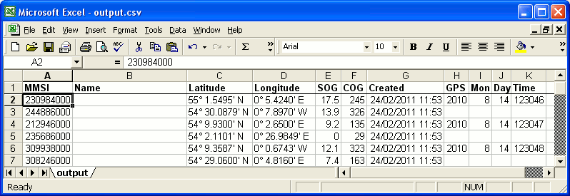
Output for import to Excel
- Display
Ships on
Google Earth
- Display
Ships on
Google Maps
- KML,
KMZ or XML Output to
Google Earth
or Google Maps
- HTML
output to
website
- Output format may be
tailored to
individual requirements
- Output filtering by
individual AIS
Message Fields
- Output filtering by any
Field value (for
example Area by Latitude and Longitude)
- Reads NMEA log files
- Filters NMEA AIS log
files by all
message types and all AIS fields
- Reads ShipPlotter
spnmea
log files
- Can be run like a Server
There is a comprehensive Help file
distributed
with the installation file
There is also a PDF extraction of this file here.
How AIS data is Encoded
AIS data is encapsulated within the Marine Standard NMEA
protocol,
which defines Standands
for
communication
between
wired
electonic
ship
devices.
NMEA
defines
many
different
sentences,
two
of
which
are
normally
used
for
containing AIS data named !AIVDM
and !AIVDO. The content of both these sentences are identical
(!AIVDM
is transmitted, !AIVDO is on board).
Transmission
For transmission the !AIVDM sentences are sent in individual
packets
using a system called TDMA (Time Division Multiple Access). If
two
transmitters sent data at exactly the same time, a receiver
with range
of both transmitters would pick up garbled packets. TDMA
organises AIS
transmitters in such a way that each AIS transmitter does not
try and
transmit their own data packets at exactly the same time as
another
transmitter within range. Each packet transmitted lasts for
exactly
26.670 milliseconds and is transmitted on a VHF channel within
the
marine radio band. The transmission of one packet is called a
slot,
during which time exactly 168 bits of data can be sent. If a
NMEA
sentence contains more than 168 bits, multiple slots are used,
the
complete message being re-assembled by the AIS receiver. This
splitting
of a AIS message into packets for transmission and the
re-assembly by
the receiver is transparent to AisDecoder, however the control
of
the slots uses specific AIS messages, which are decoded.
NMEA
Sentences
NMEA sentences are split into words separated by a comma, and
have a
maximum length of 80 characters.
eg !AIVDM,1,1,,B,13PRrB0000OvbS@NhA9=oPbr0<0u,0*58
The first word !AIVDM is the name of the sentence, the last 2
characters are the checksum.
The AIS
Payload is
the 6th word - 13PRrB0000OvbS@NhA9=oPbr0<0u
As the maximum
size of
the whole sentence is 80 characters, the payload can be no
longer than
51 characters, and may be shorter.
Because the permitted characters in a NMEA sentence are a
subset of the
8-bit ASCII character set, and the payload must be able to
contain all
bits, each 8 bit character in the payload can only represent 6
bits of
data. Every 6 bits of AIS data has to be encoded into one 8
bit ASCII
character, prior to transmission. One NMEA AIS sentence can
only
contain a maximum of 306 bits.
If an AIS message is longer than 306 bits, each AIS message
must be
split into "multi-part" NMEA sentences. Words 2,3 and 4 are
the no of
parts, this part and a part id. The 5th word is the AIS radio
channel
which has been used for transmission.
AIS Messages
AIS messages are contained entirely in the payload (6th) word
of a NMEA
sentence or in the case of multi-part messages in multiple
payloads,
after re-assembly by the decoder. The messages, of which there
are 27
basic types, are split into separate fields. Each field
contains a
number of bits. These fields are also encoded as they could
represent
numerical data (eg speed) or textual data (eg vessel's name)
or require
conversion from a numeric code to a meaningful description (eg
type of
vessel where 50 = Pilot Vessel). AisDecoder decodes around
1500
separate fields.
The first 3 fields of AIS messages are always Message type,
Repeat
indicator and MMSI.
Binary
AIS
Messages
AIS messages 6,8, 25 and 26 are called binary messages
because
the content of the decoded message can in itself contain
binary data.
In the case of the first two (6 and 8) these messages are
further
subdivided to a further two or three sub levels of different
types
messages.
The first sub level is by Designated Area Code (DAC) for example
where DAC=1 is for
international messages.
The next sub level is by Function Identifier (FI) for example
where 2 =
Vessel/Lock scheduling
The next sub level is by Identifier (ID) for example where 1 =
Lockage
order
Sample
Displays and Outputs
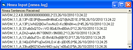
NMEA Input (Time Stamp
Appended)
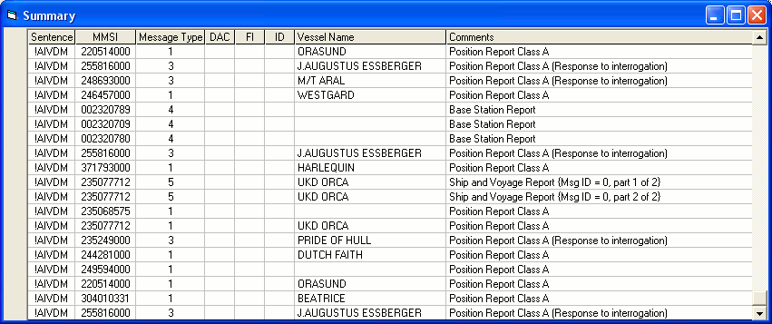
Summary
Display
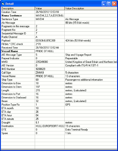
 Detail Display
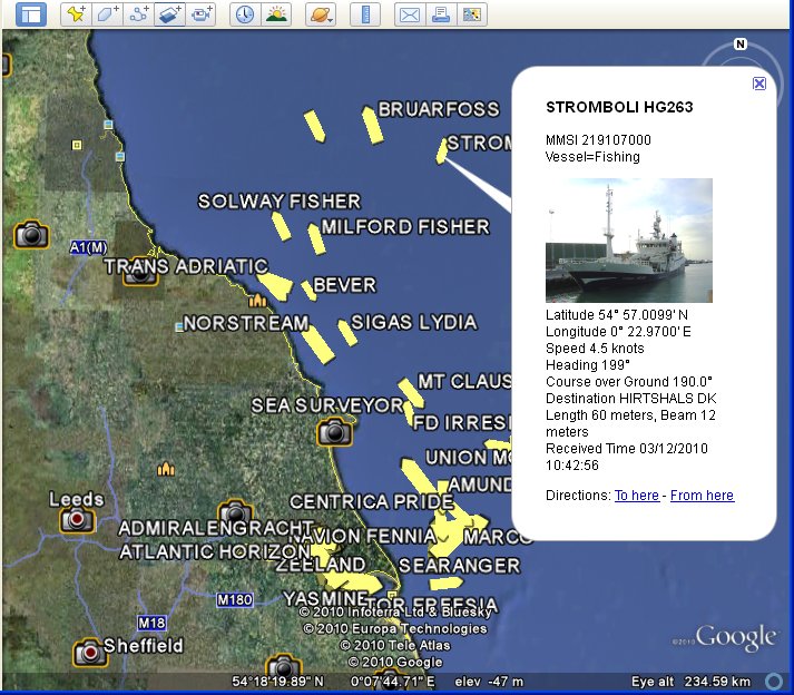
Google
Earth
Display
HTML Browser Display
You can output any message
fields - this
is a simple example

Source of HTML Browser Display
(Browser may wrap lines)
<!DOCTYPE HTML PUBLIC "-//W3C//DTD HTML 4.01 Transitional//EN" "http://www.w3.org/TR/html4/loose.dtd">
<html><head>
<title>Ais Decoder</title>
<meta http-equiv="Content-Type" content="text/html; charset=iso-8859-1">
<style type="text/css">
<!--
.html_head {font-size: 10px; color: #000000; font-family: arial, sans-serif; }
.content_header {color: #ff0000; }
-->
</style>
</head>
<body>
<table class="html_head">
<tr class="content_header"><td>Name</td><td>Position</td><td>Course</td><td>Speed</td></tr>
<tr><td>PUCCINI</td><td>54° 4.3101' N, 0° 19.6000' E</td><td>165.0</td><td>11.4</td></tr>
<tr><td>KEY FIGHTER</td><td>53° 38.0090' N, 0° 11.3053' W</td><td>190.0</td><td>0.0</td></tr>
<tr><td>CITY OF WESTMINSTER</td><td>53° 44.7599' N, 0° 17.6800' W</td><td>142.0</td><td>0.1</td></tr>
</table></body></html>
Google Maps XML Display Simple Example
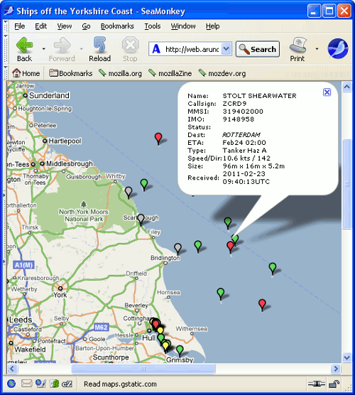
XML Example Source of Google Maps Display
(Browser may
wrap
lines)
<markers>
<marker lat="53.648310" lon="-0.208423" name="FS
PHILIPPINE"
dx="0.000" dy="0.000" type="Tanker-carrying DG,HS,MP,IMO haz
or
pollutant X"
ais="228320800!9310305!FMDU!IMMINGHAM!0222:0930!0.0!79.0!!Under
way
sailing (Rule 25)!140!23!8.8!22/02/2011 17:40:57!Ship and
Voyage
Report"/>
<marker lat="54.035500" lon="0.206833" name="" dx="0.000"
dy="0.000"
type="" ais="250000962!!!!:!13.3!135.0!!Under way using engine
(Rule
23(a) or Rule 25(e))!!!!22/02/2011 17:40:57!"/>
<marker lat="53.738860" lon="-0.260938" name="" dx="0.000"
dy="0.000" type="" ais="304970000!!!!:!0.0!285.0!!Under way
using
engine (Rule 23(a) or Rule 25(e))!!!!22/02/2011
17:41:03!"/>
<marker lat="54.441670" lon="0.698505" name="" dx="0.000"
dy="0.000"
type="" ais="419504000!!!!:!11.0!139.0!!Under way using engine
(Rule
23(a) or Rule 25(e))!!!!22/02/2011 17:40:59!"/>
</markers>
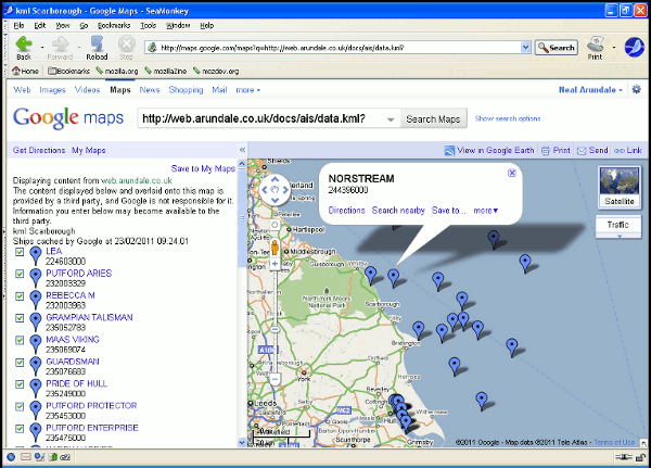
Google Maps
KML Server
Simple Example
 CSV
Output
All
Fields
-
File
(Browser
may
wrap
lines)
23/02/2011
10:43:36,,!AIVDM,1,1,,1,0,235475000,235,0,0,0.0,0,-0.294167,53.746000,39.0,272,33,0,0,0,0,0,4,1394
23/02/2011
10:43:36,,!AIVDM,1,1,,1,0,235475000,235,0,0,0.0,0,-0.294167,53.746000,39.0,272,33,0,0,0,0,0,4,1394
23/02/2011
10:43:36,AMANDINE,!AIVDM,2,2,4,5,0,253047000,253,1,9424871,LXAM,AMANDINE,71,146,49,195,15,15,30,1,02,23,07,00,7.2,KILLINGHOLME,0,0
23/02/2011
10:43:36,,!AIVDM,1,1,,1,0,232079000,232,0,0,15.8,0,0.257683,53.836980,335.0,332,38,0,0,1,0,0,0,2253
23/02/2011
10:43:36,CORAGGIO,!AIVDM,1,1,,1,0,247188200,247,0,0,0.1,0,-0.230233,53.666580,144.0,144,35,0,0,0,0,0,1,10,43
23/02/2011
10:43:37,,!AIVDM,1,1,,1,0,232003329,232,0,-128,3.4,0,0.625418,53.970200,20.0,511,38,0,0,0,0,0,7,18
23/02/2011 10:43:37,AMUR
2524,!AIVDM,1,1,,1,0,273324000,273,0,-127,6.7,0,0.452878,54.147750,150.0,156,39,0,0,0,0,0,0,2294
23/02/2011
10:43:37,,!AIVDM,1,1,,1,0,236263000,236,0,16,13.7,0,0.400488,54.035790,324.0,323,38,0,0,1,0,0,2,1450
23/02/2011 10:43:37,SIGAS
CHAMPION,!AIVDM,1,1,,1,0,564120000,564,0,0,11.4,0,-0.137148,54.574670,327.0,326,39,0,0,0,0,0,5,1
23/02/2011
10:43:37,,!AIVDM,1,1,,1,0,308583000,308,0,-127,2.5,0,0.548317,54.574230,175.0,176,40,0,0,1,0,1,1,24,60
CSV
Output
All
Fields
-
Display
(for
clarity
the
first
2
columns
are
removed)

CSV
Output
All
Fields
-
Excel
(for
clarity
the
first
2
columns
are
removed)

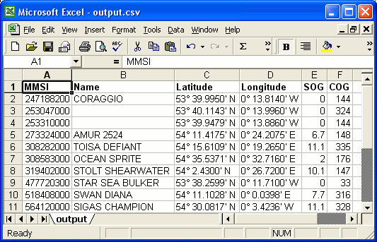
CSV Decoded
Output
Selected Fields - File
(Browser
may
wrap
lines)
247188200,CORAGGIO,53°
39.9950'
N,0°
13.8140'
W,0.0,144.0
253047000,,53° 40.1143' N,0° 13.9960' W,0.0,324.0
253310000,,53° 39.9479' N,0° 13.8860' W,0.0,144.0
273324000,AMUR 2524,54° 11.4175' N,0° 24.2075' E,6.7,148.0
308282000,TOISA DEFIANT,54° 15.6109' N,0° 19.2650'
E,11.1,335.0
308583000,OCEAN SPRITE,54° 35.5371' N,0° 32.7160'
E,2.0,176.0
319402000,STOLT SHEARWATER,54° 2.4300' N,0° 26.7200'
E,10.1,147.0
477720300,STAR SEA BULKER,53° 38.2599' N,0° 11.7100'
W,0.0,33.0
518408000,SWAN DIANA,54° 11.1028' N,0° 0.0398' E,7.7,316.0
564120000,SIGAS CHAMPION,54° 30.0817' N,0° 3.4236'
W,11.1,328.0
CSV
Output Selected
Fields - Display
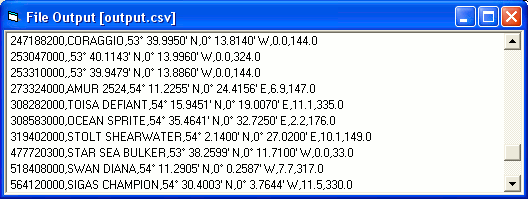
CSV Output
Selected
Fields - Excel
 SPNMEA
input
file
!AIVDM,1,1,,A,13;5<D001L00<t8NwVI5ATEF08Kc,0*7A
$GPZDA,123047,14,08,2010,+00,00*6E
!AIVDM,1,1,,A,13Pi8L0P00023hjNrlsA8?wP0<0F,0*02
!AIVDM,1,1,,A,14WU7D0OiqOwteBNw@5L`awP0D0D,0*78
$GPZDA,123048,14,08,2010,+00,00*61
!AIVDM,1,1,,A,14Uumt0Oi:00GQ0O;Ab6FTuR0L0>,0*36
!AIVDM,1,1,,A,14QsCa002Gww>8LO1T6<A9uP0D0A,0*64
!AIVDM,2,1,1,A,58UQ<802@Vj9TaIWV20pE@PE8h4pB1@T@F22220l2Hk8865E0<Tm<p8888888888,0*46
!AIVDM,2,2,1,A,8888880,2*25
$GPZDA,123049,14,08,2010,+00,00*60
SPNMEA input file, File
Output All
Fields - Display
(for
clarity
the
first
2
columns
are
removed)
 SPNMEA
input file,
CSV Output Selected Fields
- Display
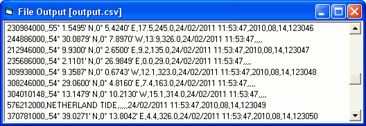
SPNMEA
input file,
CSV Output Selected Fields
- Excel
